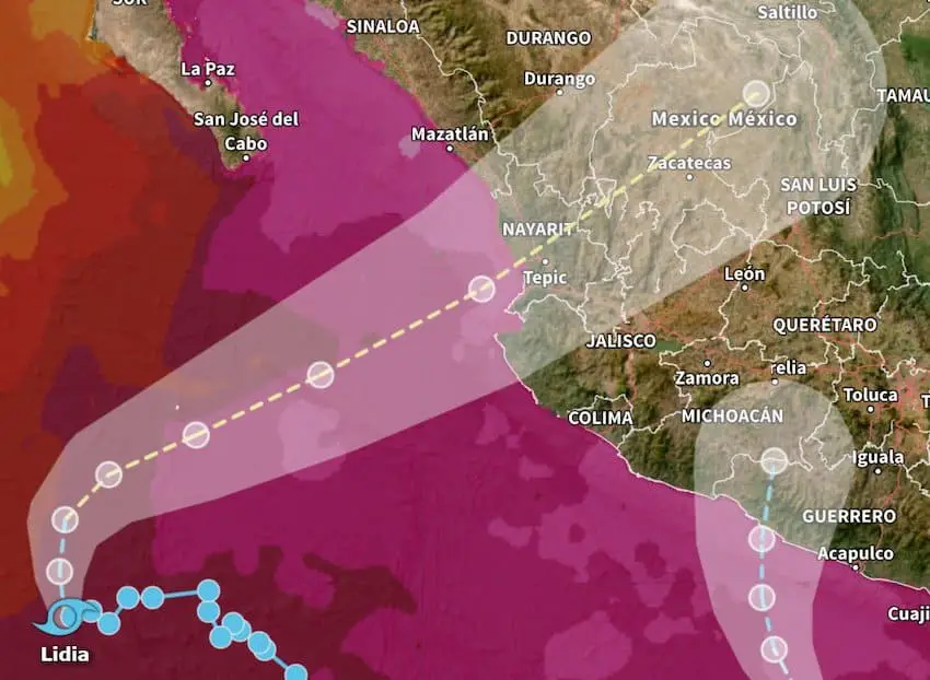
Tropical Storms Max and Lidia bring heavy rains to Pacific coast

Tropical Storm Max made landfall on the Pacific coast of Mexico on Monday, bringing torrential rain to Guerrero and Michoacán.
Max was located 31 miles (50 kilometers) south-southeast of Zihuatanejo, Guerrero, at 12 p.m. Mexico City time, according to the United States National Hurricane Center (NHC).
A tropical storm warning is in effect between Acapulco, Guerrero, and Punta San Telmo, Michoacán.
The NHC said that the storm had maximum sustained winds of 60 mph (95 km/h) and was strengthening.
“Max is moving toward the north-northeast near 5 mph (7 km/h) and this motion is expected to continue through tomorrow,” the Florida-based agency said.
“Rapid weakening is expected as Max moves inland, with the storm expected to dissipate over Mexico on Tuesday,” the NHC said.

Mexico’s National Meteorological Service (SMN) said in a statement that Max would bring torrential rain of 150-250 millimeters to Guerrero and Michoacán on Monday. “Intense” rain of 75-150 mm is expected in Colima and Oaxaca, while very heavy rain of 50-75 mm is forecast in Morelos and Puebla.
The NHC said that rains in Guerrero, Michoacán, and the coastal sections of western Oaxaca “will likely produce flash and urban flooding, along with possible mudslides in areas of higher terrain near the coast.”
The center also warned of “life-threatening surf and rip current conditions” off the southern coast of Mexico.
Authorities in Guerrero announced that classes at all schools in the state were suspended on Monday.
Meanwhile, Tropical Storm Lidia was 525 kilometers south-southwest of the southern tip of Baja California at 9 a.m., according to the NHC. Lidia is forecast to become a hurricane before making landfall in mainland Mexico on Tuesday night.
A hurricane warning is in effect between Playa Pérula, Jalisco, and Mazatlán, Sinaloa, an area that includes the entire coast of Nayarit. A hurricane warning is also in effect for the Islas Marías, an archipelago of four islands off the coast of Nayarit.

With maximum sustained winds of 100 km/h, Lidia is “moving toward the northeast near 6 mph (9 km/h),” the NHC said.
“… On the forecast track, the center of Lidia should approach Las Islas Marías on Tuesday, and move inland over west-central Mexico Tuesday night. … Strengthening is forecast later today and Tuesday, and Lidia is expected to be a hurricane when it approaches Las Islas Marías and the coast of west-central Mexico.”
A tropical storm warning is in effect between Escuinapa and Bahía de Tempehuaya in Sinaloa, and between Manzanillo, Colima, and Playa Pérula.
Lidia is forecast to bring intense rains to Baja California Sur, Sinaloa, Durango, Nayarit and Jalisco, the SMN said.
The NHC said the storm is expected to produce rainfall of 10 to 20 centimeters (4-8 inches) with local maximums of 30 cm (12 inches) “through Wednesday across the state of Nayarit, southern portions of the state of Sinaloa and coastal portions of the state of Jalisco.
“… These rains will likely produce flash and urban flooding, along with possible mudslides in areas of higher terrain near the coast.”

The NHC also said that a storm surge is expected to produce “significant coastal flooding near and to the south of where the center [of Lidia] makes landfall.”
“Near the coast, the surge will be accompanied by large and dangerous waves,” the agency said.
Authorities in Nayarit and Baja California Sur canceled classes on Monday, although the full force of Lidia isn’t expected until Tuesday.
Lidia is the 12th named storm of the 2023 Pacific hurricane season, while Max is the 13th. The season officially began on May 15 and runs through Nov. 30.
Mexico News Daily
Source: Mexico News Daily

